Where to Bird: Traditional Map
Click on any site name for more information.
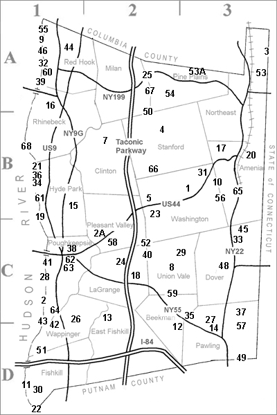
KEY TO CODESSite Access TypesC can be birded from a CAR HabitatsL LAKES, ponds, or creeks Site Description CodesIn the descriptive text below, the name of each birding site is followed by a series of codes. For example, the first site is followed by CE, MOF. As indicated in the Key to Codes at left, CE indicates that the site can be birded from a CAR and is suitable for an EASY walk. The second set of letters, MOF, describe the habitats that can be found, in this case MARSHES, OPEN areas, and FORESTS.
|
#
|
Birding Site |
Map
Loc |
#
|
Birding Site |
Map
Loc |
| 1 | Andrew Haight Rd. |
3B | 35 | Nuclear Lake | 3C | |
| 2 | Bowdoin Park | 1C | 36 | Ogden Mills State Park | 1B | |
| 2A | Bower Park | 2C | 37 | Pawling Nat Rsv/QuakerLRd | 3C | |
| 3 | Brace Mountain | 3A | 38 | Peach Hill Park | 1C | |
| 4 | Buttercup Farm Sanctuary | 2B | 39 | Poet’s Walk Park | 1A | |
| 5 | Cary Institute (arboretum) | 2B | 40 | Pond Gut | 2C | |
| 7 | Clinton Nature Garden | 2B | 41 | Poughkeepsie Rural Cemetery | 1C | |
| 8 | Clove Road / Sylvan Lake | 2C | 42 | Reese Park | 1D | |
| 9 | Cruger Island | 1A | 43 | Reese Sanctuary | 1D | |
| 10 | Deep Hollow Road | 3B | 44 | Rockefeller/Pitcher Lanes | 1A | |
| 11 | Denning’s Point Park | 1D | 45 | Roger Perry Mem. Preserve | 3C | |
| 12 | Depot Hill MUA | 2D | 46 | Saw Kill / Bard Field Station | 1A | |
| 13 | Dutchess Rail Trail | 2C | 48 | Slocum-Mostachetti Preserve | 3C | |
| 14 | Edward R Murrow Park | 3D | 49 | S. QuakerHill/TowerHill Roads | 3D | |
| 15 | Eleanor Roosevelt NHS (Valkill) | 1B | 50 | Stissing Mountain MUA | 2A | |
| 16 | Ferncliff Forest | 1A | 51 | Stony Kill Farm Env. Ed. Ctr. | 1D | |
| 17 | FlintHill / Huckleberry Roads | 3B | 52 | Taconic-Hereford MUA | 2C | |
| 53A | The Fly | 3A | 53 | Taconic SP (Rudd Pond) | 3A | |
| 18 | Freedom Park | 2C | 53A | The Fly | 3A | |
| 19 | Franklin D. Roosevelt NHS | 1C | 54 | Thompson Pond Preserve | 2A | |
| 20 | Harlem Valley Rail Trail | 3B | 55 | Tivoli Bays WMA (Kidd Lane) | 1A | |
| 21 | Hopeland Area | 1B | 56 | Tower Hill Road | 3B | |
| 22 | Hudson Highlands State Park | 1D | 57 | Tracy Road | 3D | |
| 23 | Innisfree Garden | 2B | 58 | Traver Pond (Freedom Road) | 2C | |
| 24 | James Baird State Park | 2C | 59 | Tymor Forest Park | 2C | |
| 25 | Lafayetteville MUA WilburFlts | 2A | 60 | Unific. Th. Sem. Father’s Trail | 1A | |
| 26 | Lake Oniad | 1C | 15 | Valkill (Eleanor Roosevelt) | 1B | |
| 27 | Lakeside Park (Holiday Hills) | 3C | 61 | Vanderbilt Mansion NHS | 1B | |
| 28 | Locust Grove / S. Morse NHS | 1C | 62 | Vassar College | 1C | |
| 29 | Mack Road | 2C | 63 | Vassar Coll Ecol Prsv (Farm) | 1C | |
| 30 | Madam Brett Park | 1D | 64 | Wappinger Lake | 1C | |
| 31 | Millbrook School | 3B | 65 | Wassaic MUA | 3B | |
| 32 | Montgomery Place | 1A | 66 | Whitlock Preserve | 2B | |
| 33 | Nellie Hill Preserve | 3C | 67 | Wilcox Memorial Park | 2A | |
| 34 | Norrie State Park | 1B | 68 | Wilderstein Historic Site | 1B |
Birding Locations
Can’t find the name you’re looking for? Check the Local Names Directory.
1 – Andrew Haight Road (Haight Marsh) – CE, MOF Town of Washington
Year-round. Varied habitat. Sparrows, pipits, Horned Lark, Snipe, Killdeer, warblers, ducks, shorebirds. Walking distance: 1. 5 miles (easy to moderate).
DIRECTIONS: From US 44 in Mabbettsville, turn north on North Mabbettsville Road and drive approximately one mile and take Andrew Haight Road to the right. Drive past the barns and marsh to the top of the hill and park. 160 Andrew Haight Rd, Millbrook, NY 12545
2 – Bowdoin Park – ED, HMOF
A 300-acre county park on the Hudson River in the Town of Poughkeepsie. Varied habitat. Year-round but best in spring. Nature trails (easy to moderate). Warblers and woodland species, hawks, herons, sparrows, Eastern Screech-Owl. Ducks on the river late fall through early spring; eagles in late winter. Allow 1-3 hours.
DIRECTIONS: From Poughkeepsie, go south on US 9 to Old Post Road. Take Old Post Road west to Sheafe Road and go south about 2 miles to the park entrance. From NY 9D in Wappingers Falls, take DeLavergne Road to Sheafe Road; go left on Sheafe Road to the park entrance. 127 Sheafe Rd Wappingers Falls, NY 12590
2A – Bower Park – E, SOF
A Pleasant Valley Town Park with a soccer field and access to the Bower – Quarry Trails, in cooperation with Dutchess Quarry and Supply. The 1. 5 miles of mostly level trails traverse woods, meadows, and shrubby places along Wappingers Creek. Spring, summer, and fall. Sparrows, flycatchers, warblers, and other birds of woodlands and meadows.
DIRECTIONS: From Poughkeepsie, take US 44 east to Pleasant Valley. Turn left onto North Ave. , go . 6 miles and take Ravine Rd. to the right and the park entrance is right there on the left side of Ravine Rd. 23 Ravine Rd, Pleasant Valley 12569
3 – Brace Mountain (Taconic State Park) – D, OF
Part of 1547 acre Taconic State Park in the Town of North East. Highest point in Dutchess County, 2311 feet, located where New York, Massachusetts and Connecticut come together. Deciduous and coniferous woodland and open areas at the summit. Spring, summer and fall. Good vantage point for fall hawk migration. Breeding Hermit Thrush and Dark-eyed Juncos, as well as other woodland species. Requires a 2-mile hike each way, moderate from the west or partially strenuous from the east.
DIRECTIONS: For access from the west, drive 5. 5 miles north on NY 22 from the traffic light in Millerton. Turn right on White House Crossing and follow it to the end. Go left onto Rudd Pond Road (CR 62) for 1/4 mile, turn right (east) onto Deer Run Road. Then turn left onto Quarry Hill Road and follow it around to the east side where fields meet woods. Here is the southern end of the South Taconic Trail. Park your car and hike the trail, following the white blazes for 2 miles to the summit. To reach the area from the east, drive to Salisbury, CT on US 44. At the town hall turn left and follow the signs to Mt. Riga Road. At Southe (Forge) Road, turn right onto unpaved Mount Washington Road. Go north several miles and look for a grassy parking area on the left. Park here. There is a steel gate at the back of the parking area. Follow the woods road trail on the other side of the gate for about 2 miles. Here it intersects South Taconic Trail. Take the trail to the left (south) a short distance to the summit. Maps of the area can be obtained for a fee from the New York-New Jersey Trail Conference, G. P. O. Box 2250, New York, NY 10116. Walking 4 miles (moderate to strenuous). 179 Quarry Hill Rd Millerton, NY 12546
Return to County Map & Birding Site List
4 – Buttercup Farm Wildlife Sanctuary (National Audubon Society) – E, SMOF Town of Stanford.
553 acres of woodlands, fields, pastures, wooded swamp. Best in spring and fall. Raptors, waterfowl, Great Horned Owl, Eastern Bluebird, and many resident nesting species.
DIRECTIONS: Midway between Stanfordville and Pine Plains on NY 82. Entrance to the east side is indicated by a small sign leading to a parking area. To get to the western entrance, take Route 82 and take Stissing Road, which goes off to the west about 1. 5 miles north of Cold Spring Road (CR 53). Then continue onto Mountain Road; entrance will be on your right. Allow 2-3 hours to cover either the western or eastern part. Easy to moderate. 6862 New York 82 Stanfordville, NY 12581
Return to County Map & Birding Site List
5 – Cary Institute of Ecosystem Studies (arboretum) – CE, SOF
2000 acres in the Towns of Washington and Pleasant Valley. Trails are open to the public between April 1 and October 31 from sunrise to sunset. Varied habitat. Owls, thrushes, Red-breasted Nuthatch, Eastern Bluebird, American Kestrel, Red-tailed Hawk, Wild Turkey, warblers, and the usual resident birds. Other attractions include Gardens and Greenhouse. Good handicapped access. Walking distance:2. 5 miles on the trails (easy to moderate). Allow 2-4 hours.
DIRECTIONS: Drive west from the traffic light just south of Millbrook on Rt. 82 to Sharon Turnpike (Rte. 44) and turn right. Proceed to Gifford House on the left and park and register there.
Return to County Map & Birding Site List
7 – Clinton Nature Garden – E, SOF 1215 Centre Rd, Rhinebeck, NY 12572
Return to County Map & Birding Site List
8 – Clove Road, Verbank to Sylvan Lake – C, LOF Towns of Union Vale and Beekman.
A driving trip with many stops. Open country, swamps, spruce plantings, wooded areas. Best in spring and fall, with waterfowl on the lakes most plentiful in late fall and early spring. Driving distance: 20 miles. Allow 2-3 hours.
DIRECTIONS: Start in Verbank on NY 82. Turn southeast on Clove Road (CR 9), stop at Abel’s Pond on the left, and continue until you come to a T-intersection. Go right and makes stops whenever you see birds. Look for Clove Cemetery on your left and proceed in to Christie Pond, a duck breeding pond. Continue down Clove Road to NY 55 (traffic light). Cross NY 55; you are now on Beekman Road. Drive several miles and take Sylvan Lake Road (CR 10) to the right. Drive to the lake and stop. Continue on Sylvan Lake Road to NY 82. 3200 Sylvan Lake Rd, Hopewell Junction, NY 12533
Return to County Map & Birding Site List
9 – Cruger Island (Hudson River National Estuarine Research Reserve) – E, HMF
60 acres on the Hudson River in the Town of Red Hook. Bay, estuary, tidal marsh, mudflats, tidal swamp, woodlands. An excellent area for all kinds of birds, with waterfowl and shorebirds most plentiful. Osprey, Northern Harrier, Marsh Wren, Least Bittern, Virginia Rail. Best in early spring and late summer; also excellent for observing ducks on the river in late fall. Walking distance:2 miles (moderate). Allow 4-6 hours.
DIRECTIONS: Take NY. 9G north toward Annandale and Tivoli. Turn left onto CR 103 (Annandale Road) about 5 miles north of the Rhinebeck intersection of US 9 and NY 9G. Where CR 103 takes a sharp turn to the left, go down Cruger Island Road. Park your car at one of the state MUA lots (you will pass some Bard College dorm lots; do not park in these). Walk the road. Cross the railroad tracks carefully to get over to the island and be aware of the tides so that you don’t get stranded. 74 Cruger Island Rd Tivoli Bays, Red Hook, NY 12571
Return to County Map & Birding Site List
10 – Deep Hollow Road – CE, SF
A 3-mile stretch along a public road in the Towns of Washington and Amenia. The road follows a section of the Wassaic Creek through wooded areas. Good in all seasons except winter. Acadian Flycatcher, Winter Wren, Dark-eyed Junco, Louisiana Waterthrush, Blue-headed Vireo, Black-throated Green Warbler, and many others. Walking or driving distance:3 miles (easy). Allow 2-4 hours.
DIRECTIONS: (a) From Millbrook, drive east on US 44 for about 4. 5 miles to Lithgow and turn right onto Deep Hollow Road. (b) Alternatively, take NY 22 to Wassaic and turn west onto Deep Hollow Road. Park your car just off Rte. 22 and walk the roadsides. Deep Hollow Rd, from Rt 22, Amenia NY 12501
Return to County Map & Birding Site List
11 – Denning’s Point Park – E, HF
100 acres on the Hudson River in the City of Beacon, Dennings Point was added to Hudson Highlands State Park in 1988. Trail (an old woods road) through heavily wooded grounds. Woodpeckers, warblers, vireos. Waterfowl can be seen from several vantage points. Walking distance: 1. 2 mile (easy). Allow 3 hours.
DIRECTIONS: Denning’s Point is at the southernmost end of the city, at the mouth of the Fishkill Creek. Take Route 9D into Beacon. Turn south on South Ave. and then immediately make a right onto Dennings Ave. Park across from Beacon Water Treatment Plant. Walk up the trail; cross the bridge across the Metro North tracks. 100 Dennings Ave, Beacon, NY 12508
Return to County Map & Birding Site List
12 – Depot Hill Multiple Use Area – ED, SBF
260 acres in the Town of Beekman. Heavily wooded with some brushy areas and streams. Hawks, Ruffed Grouse, Hermit Thrush, warblers (including Louisiana Waterthrush, Hooded and Canada), Yellow-bellied Sapsucker. Also bird along Depot Hill Road in the nearby vicinity. Appalachian Trail crosses Depot Hill Road just to the north of the MUA. Walking distance:1-2 miles (easy to moderate). Allow 3-4 hours.
DIRECTIONS: Take NY 55 to traffic light at NY 216 and then take NY 216 one mile to Depot Hill Road. Turn left onto Depot Hill Road and drive about 2. 5 miles, passing the Appalachian Trail parking area and the communication towers. Look for the MUA parking lot on your left. It is suggested that you return by the same route as Depot Hill Road is extremely rugged beyond the MUA. 273 Depot Hill Rd, Holmes, NY 12531
Return to County Map & Birding Site List
13 – Dutchess Rail Trail – E, MOBF
The 12-mile rail trail extending from the Hopewell Junction RR depot to Morgan Lake is nearly complete. The trail passes through the Towns of Poughkeepsie, Lagrange, Wappingers, and East Fishkill. The sections good for birding include Hopewell Junction Depot to Van Wyck Lane which passes by Lake Walton. Migrating waterfowl can be seen here. Another section for birding is from Gold’s Gym on Titusville Road to behind H. G. Page’s on Rt 55. Habitat ranges from shrubby to more mature woodlands. The section from Diddell Road to Van Wyck Land crosses Sprout Creek and goes through some woodlands. Trailheads/Parking Lot Locations: Morgan Lake: 16 Creek Rd, Poughkeepsie, NY 12601 Overocker Road: 58 Overocker Rd, Poughkeepsie, NY 12603 Titusville & Old Manchester Roads: 32-34 Titusville Rd, Poughkeepsie, NY 12603 Titusville & Daley Roads: 264-288 Titusville Rd, Poughkeepsie, NY 12603 (park in Gold’s Gym parking lot) Didell Road: 24 Diddell Rd, Rt 376, Wappingers Falls, NY 12590 Van Wyck Lane: 44 Van Wyck Ln, near Rt 376, Wappingers Falls, NY 12590 Railroad Avenue: 84 Railroad Ave (off Rt 376), Hopewell Junction, NY 12533
Return to County Map & Birding Site List
14 – Edward R. Murrow Park – E, OBF
82 acres in the Town of Pawling. Pond and varied habitat with nature trails. Best September-May. Bluebirds, kinglets, thrushes, warblers, flycatchers, pheasants, grouse, hawks, and possibly shorebirds at pond edges. Walking distance: 1-2 miles (easy). Allow 1-2 hours.
DIRECTIONS: From the center of Pawling, take West Main Street. The park is at the intersection with Lakeside Drive. There may be a fee for individual use. 190 Lakeside Dr, Pawling, NY
Return to County Map & Birding Site List
15 – Eleanor Roosevelt National Historic Site (Valkill) – E, LOBF
190 acres in the Town of Hyde Park. Lake, marsh, forest; varied habitat. Best in spring and summer. Herons, Wood Duck, Belted Kingfisher, swallows, warblers, Barred Owl, Pileated Woodpecker, Blue-gray Gnatcatcher, Common Snipe. Walking distance:1 mile. Allow 2-3 hours.
DIRECTIONS: Take NY 9G north from Poughkeepsie. Look for the entrance to Valkill about 1/2 mile north of the traffic light for the St. Andrews Rd. cutover to US9. Alternatively, continue beyond this entrance and take the next right, Franklin Road. Then take a left onto Roosevelt Road and drive about 1/2 mile to the back entrance. Creek Rd and Violet Ave (9G), Poughkeepsie, NY
Return to County Map & Birding Site List
16 – Ferncliff Forest (Mount Rutsen) – ED, MF
192-acre game and forest preserve in the Town of Rhinebeck. Pond and mixed forest with trail to top of Mt. Rutsen. Best in spring. Flycatchers and warblers, including Cerulean, Parula, and American Redstart. Tower at the summit a good place to watch for migrating hawks over the Hudson River. Walking distance: 2 miles (easy except for the moderate climb to the tower). Allow 4 hours.
DIRECTIONS: Take US 9 north from the traffic light in the center of Rhinebeck. Turn left on Montgomery Street (just before Northern Dutchess Hospital) and cross a stone bridge (you will now be on Old Post Road). Take a left onto Mt. Rutsen Road and look for a sign for the Preserve on the left. 68 Mount Rutsen Rd, Rhinebeck, NY
Return to County Map & Birding Site List
17 – Flint Hill / Huckleberry Roads – CE, OBF
A drive in the Town of Amenia with stops for birding. Fields, marshy areas, hedgerows. Late spring, early summer, fall. Hawks, geese, ducks, sparrows, Whip-poor-will. Driving distance: 2 miles. Allow 2 hours. DRIVING ROUTE
DIRECTIONS: From CR 83 north take a right onto Flint Hill Road. Make stops on Flint Hill Road and then take a left onto Cascade Mt. Road. At the end of Cascade Mt. Road, make a right onto Morse Hill Road and continue to Perry’s Corners and on to NY 22.
Return to County Map & Birding Site List
53A – The Fly – L
See below (listed after Taconic State Park).
18 – Freedom Park – E, SOF
91-acre park in the Town of LaGrange. Creek, field, wooded hillside; varied habitat. Year-round. Ducks, kinglets, woodpeckers, warblers, sparrows, bluebirds. Walking distance: 1 mile (easy). Allow 2 hours.
DIRECTIONS: Take the Taconic Parkway north past NY 55 and exit onto Skidmore Road to the east. Drive 1½ miles to the park entrance on the right. 212 Skidmore Rd, Lagrangeville, NY 12540
Return to County Map & Birding Site List
19 – Franklin D. Roosevelt National Historic Site E, HOF
290 acres in the Town of Hyde Park along the Hudson River. Lawns, woodland, orchard, meadowland, hemlock grove, pond, stream, tidal area. Nature trail; trail map. Best in spring and fall. Winter specialties include Red-breasted Nuthatch, redpolls, and Winter Wren. Many species during migration seasons. Walking distance: 2 miles (easy to moderate). Allow 3 hours.
DIRECTIONS: Take US 9 south from Hyde Park or north from Poughkeepsie. The site is well marked on the west side of US 9. Ample parking. 4079 Albany Post Rd (Rt. 9), Hyde Park, NY 12538
Return to County Map & Birding Site List
20 – Harlem Valley Rail Trail Sections 1, 2 and 3 – E, MOBF
Towns of Amenia and North East. The Harlem Valley Rail Tail is a 10-foot wide paved trail that will eventually offer 43 miles of uninterrupted travel connecting Wassaic and Chatham, NY. Birds seen have included Red-headed Woodpecker, Virginia Rail (was the trail named after this bird?), Marsh Wren, sparrows (including Swamp and Vesper), warblers, flycatchers, Northern Harrier, Raven. Section 1, opened in 2005, goes north from the Metro North station in Wassaic to Mechanic Street in Amenia. This is the southern terminus of the entire HVRT. Section 2, opened in 1996, goes north from Mechanic Street in Amenia north to Coleman Station in the Town of North East. Woodland and open areas, wetland halfway between Amenia and Coleman Station. Section 3, opened in 2000, extends from Coleman Station northward to Millerton. Picturesque rock cuts, Webutuck Creek, Ten Mile River. Walking distance: The total distance from Millerton to Amenia is 8. 2 miles (one way); Section 1 is 2. 6 miles, Section 2 is 4. 5 miles and Section 3 is 3. 6 miles. Allow at least 3 hours for each Section.
DIRECTIONS: In Amenia, take NY 343 east from the intersection of NY 22, US 44, and NY 343. Go 1/4 mile and make a right onto Mechanic Street (across from Cumberland Farms). The parking lot is 1/4 mile down the street on the left; if this lot is full, turn back and park at the town hall closer to NY 343. There is also a parking lot at Coleman Station (take Coleman Station Road, CR 58, east from NY 22). In Millerton, park at the Eugene L. Brooks Rail Trail Station behind the North East Community Center on South Center Street. At the Wassaic train station, park your car and cross the tracks where you drove in; the trailhead is on your right. Parking at the Wassaic train station is free on weekends and holidays; parking at the other trailheads is free every day. The trail is open from dawn to dusk. Trailheads/Parking Lot Locations: Wassaic Station: Wassaic MTA Railroad Station, Rt 22 Amenia, NY 12501 Amenia Station: Railroad Avenue X Mechanic Street Amenia, NY 12501 Coleman Station: Railroad Avenue X Mechanic Street Amenia, NY 12501 Millerton: Main Street X South Center St Millerton, NY 12546
Return to County Map & Birding Site List
21 Hopeland Area – E, OBF
This newly acquired 107-acre parcel is added to the Mills-Norrie State Park and is north of Dinsmore Golf Course. Check the kiosk at the parking area for a map of the trails and a history of the area. Part of the trail is handicap accessible. The trails pass through shrubby and open area as well as forested stretches. Both forest and field birds can be found here, including Prairie Warblers, Blue-winged Warblers, Field Sparrows, Indigo Buntings, Scarlet Tanagers, Great Crested Flycatchers.
DIRECTIONS: Take US 9 north from Hyde Park 3 miles to the entrance of Norrie State Park on the left. Go left onto Old Post Road and continue past Norrie Park through Staatsburg. Drive about 1/2 mile past the entrance to Staatsburgh/Mills Mansion to the sign for Hopeland on your left, immediately after the road curves right. 166 Old Post Rd Staatsburg, NY 12580
Return to County Map & Birding Site List
22 – Hudson Highlands State Park (Breakneck Ridge) – ED, HF
500 acres, partly in the Town of Fishkill. One of National Audubon’s Important Bird Areas. Oak/birch/aspen forest with some grassy and swampy areas. Best in spring and fall. Raptors including eagles and Peregrine Falcon, warblers, Field Sparrow, Indigo Bunting, Carolina Wren.
DIRECTIONS: From Beacon, take NY 9D south and park about 500 feet north of the tunnel. Walk the abandoned road (yellow trail markers) from the east side of NY 9D. Alternatively, use the steep trail (white markers) at the northern end of the tunnel, but be prepared for a strenuous and sometimes hazardous climb.
Return to County Map & Birding Site List
23 – Innisfree Garden – ED, LMOF
188 acres in the Towns of Washington and Pleasant Valley. Lake and well-maintained grounds and gardens, deciduous and coniferous woodland with trail. Best in spring. Geese, Mallards, warblers, woodland species, Ruffed Grouse. Open 10am – 5pm Wednesday Sunday from May through October. Walking distance:1 mile (easy to moderate). Allow 3-4 hours.
DIRECTIONS: From US 44 just east of the trooper barracks at the NY 82 traffic light, take Tyrell Road south 1 mile to the stone gate and follow the narrow road to the parking lot. 362 Tyrrel Rd, Millbrook, NY 12545
Return to County Map & Birding Site List
24 – James Baird State Park – CED, LOF
590 acres in the Town of LaGrange. Golf course, woodland. Roads and trails. Best in winter and spring. Green Heron, shorebirds, Horned Larks, Snow Buntings, hawks, Great Horned Owl, Ruffed Grouse, vireos, warblers, kinglets, sparrows, finches. Walking distance: 2 miles (easy). Allow 3-4 hours.
DIRECTIONS: Main entrance is from the Taconic Parkway one mile north of NY 55 and is well marked. Alternatively, enter from Freedom Road about 1 mile north of Rt. 55: 148 Freedom Rd at Baird Park Rd, Pleasant Valley, NY 12569 Return to County Map & Birding Site List
25 – Lafayetteville Multiple Use Area (Wilbur Flats Road) – CE, LMOF
715 acres in the Town of Milan. Varied habitat including open fields, swamp, a pine plantation, woodlands, and rocky ledges. Best in spring, also good in summer and fall. Pheasants, grouse, owls, thrushes, wrens, warblers, sparrows, flycatchers, ducks. The area is used by hunters in season. Walking distance:2 miles (easy).
DIRECTIONS: Drive to the MUA either via the Taconic Parkway northbound or via NY 199 from Lafayetteville. It is well marked with a wooden MUA sign. Park at the intersection of NY 199 and Wilbur Flats Road. 1938 NY Rt 199, Stanfordville, NY 12581
Return to County Map & Birding Site List
26 – Lake Oniad – C, L
A privately owned 10-acre lake in a residential area of Wappingers Falls. Best in spring and fall. Scaup, Ring-necked Duck, Bufflehead, grebes, Spotted Sandpiper, Belted Kingfisher.
DIRECTIONS: From US 9, take Myers Corners Road east for one mile and take a right onto Kent Road. Follow Kent Road to the sign for Lake Oniad and follow Lake Oniad Road around the lake. Drive along the shoreline and make quick stops to view the lake from your car. 42 Lake Oniad Dr, Myers Corner, NY 12590
Return to County Map & Birding Site List
27 – Lakeside Park (Holiday Hills) – E, LOBF
Hiking trails and lake in Pawling.
DIRECTIONS: From the center of Pawling, take Charles Colman Boulevard north about one mile to 4-way stop sign. The park is on your left. There may be a fee for individual use. 2 Lakeside Dr, Pawling, NY 12564
Return to County Map & Birding Site List
28 – Locust Grove / Samuel Morse Historic Site – E, HSOF
150 acres in the Town of Poughkeepsie. Former home of Samuel F. B. Morse. Mostly woodland between the museum and the Hudson River. Carriage roads serve as trails. Woodland and urban birds, gulls, warblers. Walking distance: 2 miles (easy to moderate). Allow 3 hours.
DIRECTIONS: Take US 9 south from Poughkeepsie to the traffic light at Beechwood Avenue. Locust Grove is on the right and has ample parking. 2683 South Rd (Rt 9) Poughkeepskie, NY 12601
Return to County Map & Birding Site List
29 – Mack Road – ED, F
Mack Road is a dead end narrow road in the Clove Valley in the Town of Union Vale. It passes through a deep hemlock ravine, a mixed hardwood forest, open and brushy areas, and pine plantations. This is a roadside birding area with several places to pull one or two cars off the road. The best parking area is at the right-angle turn about 1 mile in. Permission is not required to bird along the road. The area should be avoided during deer season. Best in spring and summer. Species observed include Great Horned Owl, Goshawk, and warblers (Yellow-rumped, Black-throated Green, Louisiana Waterthrush, Hooded, Prairie, and others). Walking distance: 1. 5 miles (easy except for the first 1/2 mile, which is rather steep). Allow 1-2 hours.
DIRECTIONS: From NY 82, take NY 55 east to the first traffic light. Turn left (north) onto Bruzgul Road and proceed to the traffic circle. At the traffic circle, turn left onto Clove Valley Road (CR 9). Mack Road is approximately 3 miles up Clove Valley Road on the right. 287 Mack Rd, Lagrangeville, NY 12540
Return to County Map & Birding Site List
30 – Madam Brett Park – ED, SMBF
12 acres in the City of Beacon, at the confluence of Fishkill Creek with the Hudson River. Waterfowl, Fish Crow, warblers, sparrows. Trail along Fishkill Creek and waterfront marshland. Raised boardwalk. Walking distance: 2 miles (easy). Allow 2 hours.
DIRECTIONS: Take NY 9D into Beacon, to South Ave. (toward the river). Turn right (south) onto Tioronda Ave. past old warehouses and then turn left and go under the railroad trestle bridge. Parking lot is on left. 552 South Ave, Beacon, NY 12508
Return to County Map & Birding Site List
31 – Millbrook School – E, SMOF
A private school in the Town of Washington. The campus includes a large marsh with boardwalk, deciduous woodland, and open fields. A cross-country ski trail can be hiked through the woods and open fields, starting near the ski tow just north of the marsh. Good any time of year but best in spring. Eastern Screech-Owl, Woodcock, Common Snipe, Virginia and King Rails, White-eyed Vireo, Willow Flycatcher, many warbler species. Over 160 species have been recorded. Walking distance: 3 miles (easy to moderate). Allow 3 hours.
DIRECTIONS: Drive west from Amenia for 4 miles (or east from Millbrook for 5 miles) on US 44 and take Millbrook School Road to the north. Park near the marsh or in the zoo parking lot. 220 Millbrook School Rd, Millbrook, NY 12545
Return to County Map & Birding Site List
32 – Montgomery Place – E, HSOF
A Hudson River estate of 434 acres just south of Bard College in the Town of Red Hook. Orchard, gardens, lawns, deciduous and hemlock woods, and a view of the Hudson. Trails. Wheelchairs can use the roads. Winter Wren, warblers, flycatchers, orioles, Pileated Woodpecker, Rose-breasted Grosbeak. Walking distance: 2 miles (easy). Allow 2-3 hours.
DIRECTIONS: Take NY 9G north to the intersection with NY 199. Turn left (west) onto NY 199. CR 103 crosses NY 199 before the Kingston-Rhinecliff Bridge. Turn right onto CR 103 north. Montgomery Place is 2-3 miles up the road on the left. Park at the Visitors’ Center. 26 Gardener Way, Red Hook, NY 12571
Return to County Map & Birding Site List
33 – Nellie Hill Preserve (The Nature Conservancy) – D, OBF
144 acres in the town of Dover. Habitat includes pocket grasslands, rich oak forest, and a previously-grazed, sloping meadow, with several springs and two ponds. Great Horned Owl, Ruffed Grouse, Blue-gray Gnatcatcher, warblers (including Prairie and Hooded), vireos (including nesting White-eyed), Brown Thrasher, orioles, sparrows, thrushes. Walking distance: 2 miles (easy to moderate). Allow 3 hours.
DIRECTIONS: NY 22 north toward Dover Plains. Pass CR 6 and proceed another 1/4 mile. Parking area is on right; preserve sign is set back from road. Follow path up the hill to a wide steel gate at the preserve entrance. 2968 Rt 22 Dover Plains, NY 12522
Return to County Map & Birding Site List
34 – Norrie State Park (Norrie Point, Mills-Norrie State Park) – CEK, HSOF
About 400 acres on the Hudson River south of and adjacent to Mills State Park in the Town of Hyde Park. Roads, boat basin, river access, Dutchess Community College Environmental Museum. Waterfowl and gulls on the river, woodland birds, wrens, thrushes, sparrows. Walking distance: 2 miles (easy). Allow 2 hours.
DIRECTIONS: Take US 9 north from Hyde Park 3 miles to the entrance of Norrie State Park on the left. Old Post Rd, Staatsburg, NY 12580
Return to County Map & Birding Site List
35 – Nuclear Lake – ED, LMF
This property in the Town of Pawling is now owned by the National Forest Service and flanks the Appalachian Trail corridor. Mostly mixed woodland with a swampy area and a lake. Many years ago a nuclear accident in a small lab here resulted in closure of the area (and the lab) as well as re-routing of the Appalachian Trail. The area has long been declared safe and the lake is again rich with wildlife; the Appalachian Trail has once again resumed its old route close to the lake. The area is especially productive during spring migration, when many warblers and other songbirds are seen.
DIRECTIONS: Take NY 55 east to Poughquag. Drive 1. 7 miles beyond the NY 216 traffic light and then take Old Rte. 55 left. The small parking lot for Nuclear Lake is unsigned and is only about 300 feet north of the intersection. 150 Old Rt 55, Pawling, NY 12564
Return to County Map & Birding Site List
36 – Ogden Mills State Park (Staatsburgh/Mills Mansion) – ED, HMOF
About 500 acres on the Hudson River north of and adjacent to Norrie State Park in the Town of Hyde Park. Trail through mixed woodland along the river and carriage roads through the old estate. Waterfowl and gulls on the river, woodland birds, wrens, thrushes, sparrows. Walking distance:2 mi. (easy to moderate). Allow 2 hrs.
DIRECTIONS: Take US 9 north from Hyde Park 3 miles to the entrance of Norrie State Park on the left. Go left onto Old Post Road and continue past Norrie Park through Staatsburg. The entrance to Staatsburgh/Mills Mansion is just north of the village and across from the golf course. 138 Mills Mansion Rd, Staatsburg, NY 12580
Return to County Map & Birding Site List
37 – Pawling Nature Reserve (The Nature Conservancy) – CED, LMF
1060 acres in the Town of Pawling. Mostly upland forest; also includes a hemlock gorge and swampy areas. Good in all seasons, especially during migration. Deer hunting is allowed in season. Nesting birds include Hermit Thrush, Black-throated Blue, Hooded, and Canada Warblers, Winter Wren, Acadian Flycatcher, Brown Creeper, and Barred Owl. Wild Turkey, Ruffed Grouse, and Red-shouldered and Broad-winged Hawks are also seen here. Walking distance: 3 miles (easy on the road; easy to strenuous on the trails). Allow 3-4 hours.
DIRECTIONS: From Pawling, take NY 22 north for 2 miles to North Quaker HillRoad (CR 68). Go right on CR 68 and follow this road about 1. 5 miles to Quaker Lake Road. Take Quaker Lake Road to the left (north) and drive past Quaker Lake on the left. Continue until you come to the Nature Conservancy parking lot on the left. 125 Quaker Lake Rd, Pawling, NY 12564
Return to County Map & Birding Site List
38 – Peach Hill Park – ED, OBF
158 acres at the highest elevation in the Town of Poughkeepsie. Apple orchards and beautiful views.
DIRECTIONS: From the south or southeast, drive to Arlington, and take Rte. 44/55 west toward the river. Take Innis Avenue north (right turn) to Salt Point Turnpike (CR 115). Turn right, go past the Bedell Rd. intersection, and take the next right onto Edgewood Drive. The park is at the intersection of Edgewood Drive and Patricia Road. From Pleasant Valley or the northeast, take Salt Point Turnpike (CR 115) west (toward Poughkeepsie). Take the third left after Cream Street onto Edgewood Drive and proceed as above. From the north, take SR 9G to East Dorsey Lane. Turn left (east) onto East Dorsey Lane and go straight at the intersection with Creek Road. Take the next right, which is the continuation of East Dorsey Lane, and continue to the “T” intersection with Cream Street. Turn right on Cream Street, and then right onto Salt Point Turnpike (CR 115). Take the third left onto Edgewood Drive and proceed as above. 36 Edgewood Dr, Poughkeepsie, NY 12601
Return to County Map & Birding Site List
39 – Poet’s Walk Romantic Landscape Park – E, HOF
120 acres in the Town of Red Hook with varied habitat and great views of the Hudson River. Grassland and woodland birds, including Bobolink and Orchard Oriole. Walking distance:2 miles. Allow 3 hours.
DIRECTIONS: Take NY 9G north and then NY 199 (toward the Kingston-Rhinecliff Bridge). Make a right (north) off 199 onto River Road and watch for the park entrance on the left. 785 River Rd, Red Hook, NY 12571
Return to County Map & Birding Site List
40 – Pond Gut (Susie Quinn’s) – ED, MF
A part of the Taconic-Hereford MUA with separate access in the Town of LaGrange west of Verbank. Varied habitat with a pond, stream, and trails. Good year-round but best in spring. Warblers, Willow and Acadian Flycatchers, hummingbirds, Blue-gray Gnatcatcher, Indigo Bunting, thrushes, owls, nesting Goshawk. Used by hunters in season and snowmobilers in winter. Walking distance: 2 miles (easy to moderate). Allow 2-4 hours.
DIRECTIONS: 1. 5 miles south of Verbank, drive west from NY 82 onto Skidmore Road. Make a right onto Gidley Road and then another right onto Pond Gut Road, which has a parking lot at its dead end. Alternatively, from the Taconic Parkway between Rt 44 and 55, go east onto Rossway Road, then left on Downing Road, left on Gidley Road, and left onto Pond Gut Road. 95 Pond Gut Rd, Pleasant Valley, NY 12569
Return to County Map & Birding Site List
41 – Poughkeepsie Rural Cemetery – CE, HLOF
30 acres in the Town of Poughkeepsie with many trees, a lake, and a view of the Hudson River. Woodland and urban birds, gulls, ducks, warblers, thrushes. Good year-round but best in spring. Roadways and trails. Walking distance: 1 mile (easy to moderate). Allow 2 hours.
DIRECTIONS: Just south of the City of Poughkeepsie (on the west side of US 9). Take the Academy Street exit from US 9; go south to the cemetery entrance. To get to the lake once inside, keep left down the hill. 342 South Ave, Poughkeepsie, NY 12601
Return to County Map & Birding Site List
42 – Reese Park – DK, LF
38 wooded acres in the Town of Wappinger. This park is the focal point/junction for the Town of Wappinger Greenway Trail Network. It is a key segment in the Hudson River Valley Greenway System. The Wappinger Greenway Trail is a 10. 7 mile figure 8 loop of on and off-road trails encircling the lower Wappinger Creek and the Wappinger Lake.
DIRECTIONS: From 9D take New Hamburg Road (CR28, the continuation of Old Hopewell Road). Before you get to the bridge that crosses the Wappingers Creek to New Hamburg, make a sharp right onto Creek Road. Go about a mile down Creek Road towards Wappingers Falls and turn right into Reese Park. 214 Creek Rd, Wappingers Falls, NY 12590
Return to County Map & Birding Site List
43 – Reese Sanctuary (Putnam Highlands Audubon Society) D, LF
98 acres in the Town of Poughkeepsie (Hamlet of New Hamburg) along the Wappinger Creek with marked trails. Deciduous woodland with small hemlock groves. Waterfowl including Wood Duck, woodland birds, warblers. Walking distance: 1+ mile (moderate). Allow 2-3 hours.
DIRECTIONS: From 9D take New Hamburg Rd (CR28, the continuation of Old Hopewell Rd) and cross the Wappingers Creek into New Hamburg. Go north on Bridge St and bear right onto Main Street. A few hundred yards up the street is a small park on the right. Trail begins at the far end of the parking lot by the tennis court. 46 Main St, Wappingers Falls, NY 12590
Return to County Map & Birding Site List
44 – Rockefeller Lane / Pitcher Lane (Greig’s Farm) CE, O
Roadside birding in the Town of Red Hook. Orchards and vast open fields of crop lands, strawberries, blueberries, raspberries. Best in winter. Snow Bunting, Horned Lark, Tree Sparrow, sometimes redpolls or Lapland Longspurs. In spring, look for Bobolink and Savannah and Grasshopper Sparrows. Driving/walking distance:5 miles. Allow plenty of time to wait for birds to come to the roadsides from the back of the fields.
DIRECTIONS: Take US 9 north from Red Hook about 2 miles. Turn left on Rockefeller Lane. Bird from your car along Rockefeller Lane, then turn right onto CR 79 and right again onto Pitcher Lane. Take Pitcher Lane back to US 9 and go right to Rockefeller Lane. This rectangular route surrounds Greig Farm. 170 Rockefeller Ln, Red Hook, NY 12571
Return to County Map & Birding Site List
45 – Roger Perry Memorial Preserve (The Nature Conservancy) – D, MOBF
117 acres at the base of the Taconic-Berkshire ridge in the Town of Dover. Limestone hill with sandy areas and fens. Nesting and migrating birds. Walking distance: Less than a mile (moderate).
DIRECTIONS: Take NY 22 north toward Dover Plains. Go right onto CR 6 and go about 1. 4 miles to Lime Kiln Road, where there is a bench. Make a left onto Lime Kiln Road and go about 1. 2 miles to Sand Hill Road. Go right on Sand Hill Road and drive . 2 miles to the parking lot on the right. 33 Sand Hill Rd, Dover Plains, NY 12522
Return to County Map & Birding Site List
46 – Saw Kill / Bard College Field Station – E, HSF
250 acres at Bard College on the Hudson River in the Town of Red Hook. Deciduous and hemlock woods, bay, creek. Good year-round. Ducks during migration, warblers, Bald Eagle, Osprey. Walking distance: 1 mile (moderate). Allow 2-3 hours.
DIRECTIONS: Take 9G north about 1 mile past NY 199. Take Kelley Road, the first left after crossing the Saw Kill. Turn right onto Annandale Road (CR 103) and then left onto Blithewood Rd. Park in the large lot on the left. Blithewood Rd, Red Hook, NY 12571
Return to County Map & Birding Site List
48 – Slocum-Mostachetti Preserve – E, MOBF
The 106-acre Slocum-Mostachetti Preserve is a rare “marble hill” surrounded by The Great Swamp, located in Wingdale, acquired by Oblong Land Conservancy in partnership with FrOGS. There is a marked trail on the marble hill, with a loop and several side trails. The Swamp River forms the eastern border of the Preserve. Good in spring, summer (with butterflies), and fall. Expect to see herons (heronry is nearby), warblers, sparrows, flycatchers, woodpeckers.
DIRECTIONS: The entrance shares a driveway with 3517 Pleasant Ridge Road. There is parking for only 2-3 cars when the gate is locked. Park at side of driveway access in front of gate; walk in. Best to call days ahead (845-855-5993 or email the ). Watch the Oblong Land Conservancy website for scheduled walks. 3517 Pleasant Ridge Rd, Wingdale, NY (about 1 mile west of Rt 22)
Return to County Map & Birding Site List
49 – South Quaker Hill Road / Tower Hill Road – CE, MOF
Roadside birding in the Town of Pawling. Horse farms, swamp, and woodland at high elevation with mountain laurel. Best in spring and fall. At the farms, you may find shorebirds, Eastern Bluebird, Orchard Oriole, Bobolink, Savannah Sparrow, and hawks. In the woods, look for Canada and other warblers, Swamp Sparrow, Barred Owl, Blue-headed Vireo, and Broad-winged Hawk. At Tower Hill Road you may find Northern Waterthrush. In winter watch for Saw-whet and Long-eared Owls. Driving/walking distance: 3 miles. Allow 3 hours.
DRIVING ROUTE DIRECTIONS: From Pawling, take NY 22 south to the traffic light at the Hannaford shopping center. Turn left onto Aikendale Road and then take the first right onto Ravine Road. At the end of Ravine Road, turn left onto South Quaker Hill Road and follow it until you get to the CT state line. Park here and walk back to Tower Hill Road. Go down Tower Hill Road to a brushy swamp on both sides of the road.
Return to County Map & Birding Site List
50 – Stissing Mountain Multiple Use Area (Hicks Hill State Land) – D, SF
450 acres in the Town of Pine Plains. Wooded hills, mostly deciduous with some conifer plantations. Stream and swampy areas. Best in spring and fall; avoid during hunting season. Warblers, vireos, nuthatches, kinglets, thrushes, flycatchers, hawks, owls, pheasant, Ruffed Grouse, Wild Turkey. Walking distance: 3 miles (moderate). Allow 3 hours.
DIRECTIONS: Take Rt. 199 west from Pine Plains to Hicks Hill Rd. Take Hicks Hill Rd south 3. 5 miles to the MUA. 218 Hicks Hill Rd, Stanfordville, NY 12581
Return to County Map & Birding Site List
51 – Stony Kill Farm Environmental Education Center – E, MOF
756 acres in the Towns of Wappinger and Fishkill. Varied habitat with fields, deciduous and coniferous woods, small brooks, swamps, and ponds. Best in spring and fall. Trails (map available at the Manor House). Waterfowl, Ruffed Grouse, hawks, woodpeckers, Eastern Meadowlark, sparrows. Walking distance: 3 miles (easy). Allow 3-4 hours.
DIRECTIONS: Take NY 9D north for 2 miles from Beacon or south for 1. 5 miles from Wappingers Falls. Park at the Manor house near the north entrance or in the lot near the barns at the south entrance. 69 Farmstead Ln, Wappingers Falls, NY 12590
Return to County Map & Birding Site List
52 – Taconic-Hereford Multiple Use Area – E, SF
909 acres in the Towns of Pleasant Valley and LaGrange. Woodland, orchards, wetlands, streams. Best May-October. Warblers, thrushes, flycatchers, nuthatches, kinglets, Goshawk, Broad-winged Hawk, Barred and Great Horned Owls. Avoid during hunting and snowmobile seasons; also popular with other offroad vehicle enthusiasts. Trails and old farm roads. Walking distance: 2 miles (easy). Allow 2-4 hours.
DIRECTIONS: 1 – Take US 44 east from the Taconic Parkway about one mile. Turn right onto South Road, then take the first right onto Tyrell Road. Drive about 2. 5 miles and look for the brown MUA sign. 200 Tyrell Rd, Pleasant Valley, NY 12569 2 – Alternatively, enter the MUA directly off the northbound Taconic State Parkway. Northbound Taconic Parkway, north of Rossway Rd
Return to County Map & Birding Site List
53 – Taconic State Park (Rudd Pond) – E, LOF
1250 acres in the Town of North East with a one-mile-long pond, woodlands, fields, marshes. Best for waterfowl in early spring and late fall. Other birds include warblers, kinglets, creepers, and finches. Walking distance: 3 miles (easy on the road, moderate on the trails). Allow 3-4 hours.
DIRECTIONS: Take US 44/NY 22 north to Millerton and continue east into Millerton on US 44 after NY 22 branches off to the north. Turn left onto Maple Avenue (CR 62, which becomes Rudd Pond Road). Go about 2 miles on CR 62 and enter the park right after the pond on the right. 274 Rudd Pond Rd, Millerton, NY 12546
Return to County Map & Birding Site List
53A – The Fly – L
Previously also known as “Dotty’s Pond. ” This small pond is in Dutchess County but right on the Columbia County Line. It is used by many kinds of waterfowl, especially in the cold winter months when it does not ice over completely (while most other ponds do). At other times it is a stopover for migrating shorebirds such as yellowlegs and Pectoral and Semipalmated Sandpipers. The only drawback of this site is that it is on private property and can only be viewed from a relatively busy road that has no shoulders along the pond. There is a small area where you can pull your car over at the north end of the pond (on the pond side of the road). You can bird from your car there, or bird carefully from the road, staying very close to the guard rail. You may get honked at (and not just by Canada Geese!).
DIRECTIONS: From the Pine Plains traffic light (where Rt. 199 from the west meets Rt. 82 from the south), take Rt. 199/82 east 1. 4 miles. Make a left turn to continue on 82. Drive about 1. 6 miles (passing the pond on your left) and turn around at Dam Road, just north of the Columbia County line. Drive back to the pond and pull over just before the guard rail begins.
Return to County Map & Birding Site List
54 – Thompson Pond/Stissing Mountain (The Nature Conservancy) ED, LMF
507 acres in the Town of Pine Plains. Woodlands, wetlands, open water. Best in spring and fall. Trails around the pond and up Stissing Mountain. 162 species of birds recorded, including warblers, ducks, Turkey Vulture, rails, Winter Wren, Swamp Sparrow, woodpeckers, Golden Eagle, and Bald Eagle. Walking distance: 3-4 miles (easy unless you climb the mountain). Allow 3 hours to walk around the lake.
DIRECTIONS: From NY 82 in Pine Plains, turn west at the firehouse onto Lake Road. Drive about 1. 5 miles across the causeway to the main entrance. 335 Lake Rd, Pine Plains, NY 12567
Return to County Map & Birding Site List
55 – Tivoli Bays Wildlife Management Area (Kidd Lane) – EDK, HMBF
1722 acres on the Hudson River in the Town of Red Hook. Varied habitat including open and brushy areas, woods, and a freshwater tidal marsh. Good year-round except during hunting season. Veery, Winter Wren, Blue-gray Gnatcatcher, Field Sparrow, migrating warblers, marsh birds. Excellent views of a tidal swamp and cattail marsh. Walking distance: 3 miles (easy). Allow 4-6 hours.
DIRECTIONS: Take NY 9G north from the NY 199 intersection to Kidd Lane. Turn left onto Kidd Lane and look for the WMA sign about ½ mile in. Turn in and park, or drive the roads. 200 Kidd Ln, Tivoli, NY 12583
Return to County Map & Birding Site List
56 – Tower Hill Road – C, SOF
Roadside birding on an unpaved road in the Towns of Washington and Amenia. Open country, deciduous woodlands, stream with hemlock ravines. Best in spring and early summer. Woodland birds, Broad-winged Hawk, warblers, flycatchers (including nesting Acadian). Driving distance: 6 miles. Allow 1 hour or more.
DIRECTIONS: Take US 44 east 2. 5 miles from Millbrook. Turn right onto Tower Hill Road. Alternatively, take Tower Hill Road to the left from NY 22 about 1 mile north of Dover Plains. 900 Tower Hill Rd Millbrook, NY 12545
Return to County Map & Birding Site List
57 – Tracy Road – C, SF
A seasonal, unpaved road in the Town of Pawling. High elevations with mostly deciduous woods and a shrub swamp and reservoir at the northern end. Best in spring and summer; avoid during hunting season. Excellent for warblers, especially during migration. Species include Canada, Hooded, Worm-eating, and Black-throated Blue Warblers as well as Scarlet Tanager, Baltimore Oriole, Northern Waterthrush, and Ruffed Grouse. Walking distance: 3 miles. Allow 3 hours.
DIRECTIONS: From Pawling, take NY 22 north for 2 miles to North Quaker Hill Road (CR 68). Go right on CR 68 and follow this road about 1. 5 miles to the crossing where Tracy Road goes off to the right (Quaker Lake Road goes to the left). Turn right and drive past the houses to the beginning of the unmaintained road, at the reservoir. Tracy Road leads to Quaker Hill Road, CR 67, east of Pawling. 94 Tracy Rd, Pawling, NY 12564
Return to County Map & Birding Site List
58 – Traver Pond (Freedom Road) – C, LMO
A 30-acre shallow lake in the Town of Pleasant Valley. Marshy areas are at both ends and cultivated fields can be seen beyond the pond. Best in spring and fall. Great Blue Heron, waterfowl (including nesting Wood Duck), Common Snipe, Belted Kingfisher, flycatchers, swallows. Allow 1 hour.
DIRECTIONS: From the north, take US 44 to just east of the bridge in Pleasant Valley, then go south onto South Avenue. Bear left onto Freedom Road where Plass Road goes to the right. Drive about ½ mile to the pond and park well off the road on the shoulder. From the south, go right onto Cramer Road at the traffic light on NY 55 just west of the LaGrange post office. Immediately bear right onto Pleasant Valley-Freedom Plains Road (CR 47), which becomes Freedom Road. After Traver Road branches off to the right, go about 2 more miles to the pond on the left. 895 Freedom Rd, Pleasant Valley, NY 12569
Return to County Map & Birding Site List
59 – Tymor Forest Park – E, LMOF
A 500-acre park for Town of Union Vale residents. Varied habitat including fields, oak woods, pine plantations, and hemlock groves as well as Fishkill Creek and Furnace Pond. Best between Labor Day and June 1. Warblers, thrushes, waterfowl, hawks, Turkey Vulture, woodland species, and birds of open fields. Walking distance: 2-3 miles (easy to moderate). Allow 3-4 hours.
DIRECTIONS: Take NY 55 east from the NY 82 intersection to the next traffic light. Go north (left) onto Bruzgul Road (CR 21) and drive 1. 5 miles. Turn right at the sign for the park and park near the house and barn. 249 Duncan Rd, Lagrangeville, NY 12540
Return to County Map & Birding Site List
60 – Unification Theological Seminary / Father’s Trail – E, HSOF
Father’s Trail is on the Barrytown campus of the Unification Theological Seminary in the Town of Red Hook. The trail is open to the public as part of the Hudson River Greenway Project. Follow the signs for Father’s Trail into the campus entrance. Park in the lot on the right. The trail begins near the lot, proceeds down the hill toward the Hudson, then parallels the train tracks north to the shore of South Tivoli Bay. After following the south shore of the bay, the trail heads back up the hill to the campus, where you can follow internal roads south back to the parking lot. The trail is about 1 mile through mostly woodlands and some more open habitat. Good for spring, summer and fall, but especially when waterfowl are migrating.
DIRECTIONS: Drive north from Rhinebeck and take Route 9G past the turnoff for the Kingston-Rhinecliff Bridge. Continue 1. 8 miles on 9G and turn left onto CR82. The campus entrance is on the right after about . 9 mile. 148 Seminary Dr, Barrytown, NY 12507
Return to County Map & Birding Site List
61 – Vanderbilt Mansion National Historic Site – E, HSOF
212 acres overlooking the Hudson River in the Town of Hyde Park. Varied habitat including meadows, woodlands, ponds, streams, inlets, and bays. Best birding is in spring between the mansion and the river. Warblers, thrushes, kinglets, woodpeckers, swallows, waterbirds, gulls. Walking distance: 2. 5 miles (easy to moderate). Allow 3 hours.
DIRECTIONS: Just north of the Village of Hyde Park on US 9. The entrance is clearly marked. Vanderbilt Park Rd Hyde Park, NY
Return to County Map & Birding Site List
62 – Vassar College – E, SOF
1000 acres in the Town of Poughkeepsie (including the farm, below). Varied habitat includes a lake, marshy area, lawns with large trees, a hemlock grove, and woodland. Best in spring, late fall, and winter. Common woodland species, sparrows, Green Heron, rails, Carolina Wren, kinglets, nuthatches, owls, Yellow-bellied Sapsucker, Pileated Woodpecker. The campus has yielded some exceptional records during the Christmas and May Censuses over the years. Walking distance: 2. 5 miles (easy). Allow 2-3 hours.
DIRECTIONS: Vassar College is just outside the eastern edge of the City of Poughkeepsie, with its main entrance on Raymond Avenue (NY 376) a few blocks south of the NY44/55 arterial. Use the entrance two driveways south of the Main Gate and park in the large lot alongside NY 376 south of the greenhouses. 106 Raymond Ave, Poughkeepsie, NY 12604
Return to County Map & Birding Site List
63 – Vassar College Farm & Ecological Preserve – E, LMOF
500 acres in the Town of Poughkeepsie. Varied habitat including wooded hillside with trails, open fields, meadows, marsh, ponds, and stream. Owls including Long-eared, warblers including Prairie and Yellow, Green Heron, Wood Duck, hawks, Bobolink, Killdeer, cuckoo, flycatchers, vireos, swallows, and sparrows. Walking distance: 3 miles (easy to moderate). Allow 2-3 hours.
DIRECTIONS: From Red Oaks Mill, take NY 376 north to the traffic light where 376 becomes Raymond Avenue to the right while Hooker Avenue goes straight ahead. Make a left into Vassar College Farm and drive straight past the large barns. The parking lot is beyond the barns near the vegetable gardens and athletic fields. 80 Rombout House Ln, Poughkeepsie, NY 12503
Return to County Map & Birding Site List
64 – Wappinger Lake – CK, L
A lake in the Town of Wappinger that is crossed by US 9 south of NY 9D. Shallow in some areas, it has bays and coves somewhat hidden from view. Best in spring and fall when migrating waterfowl are present. Gulls, geese, swans, grebes, ducks (including resident Wood Duck), Belted Kingfisher, swallows, herons, shorebirds. Driving distance: 3 miles. Allow 1-2 hours.
DIRECTIONS: Take US 9 south from the intersection with NY 9D. Cross the bridge over the lake and go right onto Liss Road. Park and view the lake. Continue to North Meiser Road and bear right, go past 3 stop signs to High Street. Turn right onto High Street and go one block to Spring Street, turn right, and drive past the dead end sign for a good view of the cove. As you leave, turn right at the top of the hill onto Pelham Street and go to Mill Street. At the 90-degree bend, view the north shore of the lake. Continue to East Main Street and turn right, crossing over the bridge, and follow this to School Street. Turn right and follow School Street to Brown Street and then go left on West Street out to East Main Street. You can also view the north coves from the back end of the Wappingers cemetery, staying on the outside drive through the cemetery. East of US 9, park at the Professional Building or at Steak and Stein and walk along the shore to view the inlet. Liss Rd, Wappingers Falls, NY 12590
Return to County Map & Birding Site List
65 – Wassaic Multiple Use Area – D, BF
488 acres in the Town of Amenia. Varied habitat including forest and wetlands. Warblers (Black-throated Green, Yellow-rumped, waterthrushes), tanagers, Rose-breasted Grosbeak, Purple Finch, Ruffed Grouse, thrushes (including Hermit). Walking distance: 2-3 miles (easy). Allow 3-4 hours.
DIRECTIONS: 1 – Take NY 22 north from Dover Plains to Tower Hill Road (about 1. 5 miles north of the intersection with NY 343. Follow Tower Hill Road to the entrance. 185 Tower Hill Rd, Wassaic, NY 12592 2 – Another way to access the MUA is via Willow Lane, only about 100 yards south of Tower Hill Rd. Willow Lane and Rt 22, Wassaic, NY 12592
Return to County Map & Birding Site List
66 – Whitlock Preserve – E, MOBF
26 acres in the Town of Stanford. Varied habitat — wooded swamp, woods, open and brushy fields, and a pond.
DIRECTIONS: Take US 44 east about 3/4 mile from the Taconic to the 44/82 corner (where the trooper barracks are). Take Rt 82 north about 5 miles (go about one mile beyond the Shunpike (CR 57). Turn right onto Knight Road. There is a sign for Whitlock Preserve there. The entrance to the parking area is on the left. 20 Knight Rd, Clinton Corners, NY 12414
Return to County Map & Birding Site List
67 – Wilcox Memorial Park – CE, LOF
A 615-acre county park in the Town of Milan. Two lakes, conifer plantations, open areas, grassland, and streams. Trails. Best in early spring and late fall. Hawks, owls, Woodcock, Common Snipe, warblers, kinglets, nuthatches, finches, and woodland species. Walking distance: 2-3 miles (easy). Allow 3-4 hours.
DIRECTIONS: Take NY 199 east from the Taconic Parkway. Wilcox is east of Lafayetteville, on the right. 285 Wilcox Park Rd Stanfordville, NY 12581
Return to County Map & Birding Site List
68 – Wilderstein Historic Site – ED, HMOBF
40 acres on the Hudson in the Town of Rhinebeck with over 3 miles of trails and a Queen Anne style mansion. Varied habitat for a variety of bird species.
DIRECTIONS: From the South: 330 Morton Rd, Rhinebeck, NY 12572
Return to County Map & Birding Site List